Central Question
What changes when Central Asia is treated as a crossroads and political center rather than empty space between China, Europe, India, and the Middle East?
Start With These Dates
- c. 550 BCEAchaemenid Empire Founded
Cyrus the Great built the Achaemenid Empire from a Persian power base, creating an imperial system that connected Iran, Mesopotamia, Anatolia, and Central Asia.
- 138 BCEZhang Qian's Western Mission
The Han court sent Zhang Qian westward to seek alliances and gather knowledge about Central Asian peoples and routes.
- c. 30 CEKushan Empire Rises
The Kushan ruling line emerged from Yuezhi groups in Bactria and built a state linking Central Asia, northern India, and long-distance trade routes.
- 751 CEBattle of Talas
Tang and Abbasid forces fought near the Talas River as rival powers competed over Central Asian alliances, trade corridors, and frontier influence.
- February 1258Mongol Sack of Baghdad
Mongol forces under Hulagu captured Baghdad, ending the Abbasid caliphate's political center and shocking the Islamic world.
- December 1979Soviet-Afghan War Begins
The Soviet Union sent troops into Afghanistan to support a friendly government, beginning a long war against armed resistance.
- December 1991Dissolution of the Soviet Union
The Soviet Union formally dissolved after political reform, economic strain, nationalist movements, and failed attempts to preserve central authority.
Sources Used Here
- Encyclopaedia Britannica: Central Asia
Reference for Central Asian geography, chronology, peoples, and historical role as a crossroads.
- Cambridge University Press: The Cambridge History of Inner Asia
Specialist scholarly synthesis for Inner Asian and Central Asian peoples, steppe polities, Mongol-era history, and regional diversity.
- Oxford Research Encyclopedia of Asian History: Early Silk Roads
Peer-reviewed reference for early Silk Roads, Han-steppe relations, Central Asian exchange, and the limits of simple trade-route narratives.
- International Institute for Central Asian Studies
Regional research-institution reference for Central Asian studies, Silk Road heritage, and cross-border scholarly cooperation.
- UNESCO Silk Roads Programme
Reference for Silk Road exchange, routes, cultural contact, and cross-regional movement.
Central Asia and Steppe Worlds is designed as a route, not a folder. It gathers events that answer related reader questions about power, belief, conflict, exchange, institutions, and memory. The strongest way to read the page is to move from the earliest events toward the later ones, watching how one kind of pressure changes form across different places.
The route currently runs from c. 550 BCE to December 1991. That span lets readers compare immediate turning points with slower consequences: the founding of institutions, the spread of ideas, the shock of war or disease, and the way later societies reused earlier events as warnings, models, or symbols.
Start with Achaemenid Empire Founded, Zhang Qian's Western Mission, Kushan Empire Rises, Battle of Talas, Mongol Sack of Baghdad and then follow the internal links into people, timelines, years, maps, and source lists. The route structure stays visible when each event explains why it belongs with the others and where the next useful page is.
Compare the events by scale. Some are concentrated moments, such as a battle, proclamation, trial, or publication. Others are long processes, such as a reform movement, pandemic, trade route, or diplomatic order. Reading both types together helps prevent the page from becoming a list of dates.
A useful route keeps uncertainty visible. Historical change rarely has one cause or one clean ending, so the reader can separate background pressure, immediate trigger, turning point, result, and later memory. That pattern is what makes the atlas expandable without making the reader start over each time.
This route is also a comparison tool. After reading one event, compare it with a later event on the same page and ask what changed in scale, language, geography, technology, authority, or public memory. The comparison is often more useful than the individual summary because it reveals the pattern the topic page is built to expose. When a claim feels too neat, open the full event page and check whether the evidence supports one cause, several causes, or a contested interpretation before moving on.
Central Asia and Steppe Worlds exists to fix a common map problem. Many world-history routes leave the region as empty space between China, India, Russia, the Middle East, and Europe. This hub treats it as a center of movement, empire, trade, religion, diplomacy, conquest, and modern geopolitical pressure. The phrase covers different environments and communities across long time spans: steppe, oasis, mountain, desert, Persianate, Turkic, Mongol, Islamic, Russian, Soviet, Afghan, and post-Soviet worlds. A reader who understands that diversity can read Silk Road, Mongol, Islamic, Russian, Soviet, and Afghan histories with less distortion.
The first layer is geography. Steppe, desert, oasis, mountain, river, and caravan worlds created different political possibilities. Mobile pastoralism, horse culture, oasis cities, irrigation, caravan taxation, and seasonal movement made power flexible. States that looked stable from an imperial capital often depended on negotiating with groups who moved through landscapes that sedentary bureaucracies could not fully control.
Persia and the Achaemenids give the route an ancient imperial edge. The Iranian plateau, Central Asian frontiers, royal roads, satrapies, and tribute systems show that this region was already part of large political thinking before the Silk Road became a familiar phrase. Persian imperial practice mattered because it made distance governable while leaving local difference in place.
Zhang Qian and the Kushans make the hub a route of knowledge. Envoys, merchants, monks, horses, coins, languages, and textiles moved through Central Asian corridors. The Silk Road was not one road and not only silk. It was a shifting set of routes where information, religion, disease, military intelligence, and prestige traveled with goods.
The Battle of Talas is useful because it puts Tang, Abbasid, Turkic, and Central Asian interests into one event. The battle's later memory can be exaggerated, but its presence in the hub helps readers see Central Asia as contested by multiple imperial systems. It also shows that borderland conflict could change what courts imagined about the limits of power.
The Mongol shock belongs here even when the event page sits at Baghdad. Mongol expansion was a steppe imperial phenomenon that transformed cities, trade, military organization, taxation, communication, and fear across Eurasia. The sack of Baghdad is not only Middle Eastern history; it is also part of a steppe-world story about mobility, violence, and empire at continental scale.
Russian and Soviet layers change the route again. Central Asia became a frontier of empire, settlement, extraction, border-making, ideology, cotton, railways, deportation, education, and surveillance. Soviet rule tried to turn mobile and Islamic societies into legible republics, economies, and national categories. The dissolution of the Soviet Union then left new states with older identities and newly hardened borders.
Sputnik's launch from Kazakhstan is not a random technology node. Baikonur places Central Asia inside the Cold War, space race, military infrastructure, and scientific prestige. The event helps readers see how a region associated with caravans and steppe routes also became a launch site for modern technological rivalry.
The Soviet-Afghan War brings the route into contemporary crisis. Afghanistan's geography, Cold War intervention, Islamist mobilization, refugee movement, U.S. and Soviet strategy, Pakistan's role, and later militant networks connect Central Asia to global security politics. The war makes clear that routes can carry ideology and weapons as much as silk or scripture.
Religion and language move through the hub in layered ways. Buddhism, Islam, Persianate literary culture, Turkic languages, Mongolian political memory, Russian, and Soviet national categories all shaped belonging. A route that only follows armies misses teachers, translators, merchants, poets, pilgrims, and administrators who made Central Asia legible to neighboring worlds.
Environmental history also matters. Steppe ecology, water control, desert margins, mountain passes, cotton monoculture, the Aral Sea disaster, and climate stress connect older route systems to modern vulnerability. These topics need future pages because they show how imperial planning and environmental limits can collide across generations.
The hub does not romanticize mobility. Steppe power could connect worlds, but it could also raid, coerce, tax, displace, and destroy. Settled empires could build cities and archives, but they could also impose categories that made mobile communities easier to control. The route works best when it keeps mobility, violence, exchange, and administration in the same frame.
Modern national histories are another layer. Kazakhstan, Uzbekistan, Kyrgyzstan, Tajikistan, Turkmenistan, Afghanistan, Mongolia, Xinjiang, and neighboring regions each need more specific treatment. Soviet borders and post-Soviet sovereignty gave some identities state form while leaving other communities divided or contested. That modern map should not be projected backward too easily.
Readers also need to see Central Asia's intellectual and artistic life. Manuscripts, astronomy, medicine, poetry, architecture, textiles, music, and urban craft traditions moved through the same routes as armies and merchants. A future cluster on Samarkand, Bukhara, Merv, and Timurid culture would keep the hub from becoming only a corridor of conflict.
The best student essay frame is distance. How did different societies make distance useful? Achaemenid roads, Han envoys, Kushan coins, Silk Road monasteries, Mongol relay systems, Soviet railways, Baikonur launch systems, and Afghan supply lines all answer the question differently. That frame turns scattered events into a coherent route with visible stakes.
The hub also protects other pages from bias. Without Central Asia, East Asia looks too self-contained, Islamic history looks too Arab-centered, Russian history looks too European, and trade history looks too peaceful. This page keeps the hard middle of Eurasia visible.
The hub is especially useful as an internal-link bridge. It can send readers to East Asia through Zhang Qian and Talas, to South Asia through Kushan and Buddhism, to the Islamic World through Baghdad and trade, to Russia through Soviet collapse, and to the contemporary world through Afghanistan. Central Asia becomes the crossing point that keeps those routes from becoming isolated silos.
The reader payoff is a corrected world map. Central Asia is not a gap. It is a field where movement becomes power, where empires meet limits, where religions travel, where modern borders remain contested, and where older route logic still shapes contemporary politics.
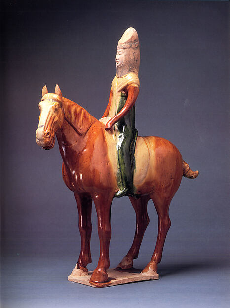
The horse-and-rider visual now fits the route better than a space-age image because movement is the route's central historical problem. Riders, pack animals, caravan towns, relay stations, mountain passes, and oasis markets explain why distance could become political leverage. The image does not stand for one culture; it signals a wider Eurasian problem of mobility, exchange, and power.
Women and households belong inside the route as well. Mobile pastoral economies depended on family labor, textiles, herding knowledge, marriage alliances, and seasonal management. Oasis cities depended on artisans, food producers, water managers, and market households. A route focused only on khans, envoys, and armies misses the social work that made movement possible and made settlement durable.
The religious layer connects Central Asia to several neighboring routes at once. Buddhism moved through monastery networks and patronage; Islam spread through merchants, scholars, rulers, Sufi networks, and urban institutions; Persianate and Turkic literary cultures gave courts and communities shared languages of prestige. The region did not simply receive religions from outside. It translated, sponsored, debated, and carried them onward.
Source tension gives the route its interpretive bite. Chinese court reports describe frontier intelligence; Arabic and Persian geographers describe routes and cities; archaeology reveals coins, textiles, walls, manuscripts, and burial goods; Russian and Soviet archives impose administrative categories; oral traditions preserve memory that official files often miss. Each source family sees movement differently.
The source trail has to work across very different evidence. Cambridge Inner Asia and Oxford Silk Roads scholarship keep the route away from a romantic one-road story. UNESCO's Silk Roads material gives the route a corridor frame; the International Dunhuang Programme makes manuscripts, printed material, and objects from the eastern Silk Roads visible; the Met rider object ties mobility to material culture; the International Institute for Central Asian Studies adds a regional research institution; Library of Congress material on Soviet Central Asia anchors the modern transformation of identity and culture; NASA's Sputnik history keeps Baikonur and Kazakhstan inside the space-race layer.
Contested interpretation is part of the route. Silk Road language can exaggerate peaceful exchange; Mongol history can flatten administration into destruction or romanticize conquest; Soviet Central Asia can be read through modernization, coercion, nation-making, deportation, and environmental damage at the same time. The hub therefore treats event pages as evidence checkpoints. Zhang Qian, Talas, the Mongol sack of Baghdad, Sputnik, Afghanistan, and Soviet dissolution should each show what kind of source is carrying the claim and what interpretation remains open.
The modern route also needs economic specificity. Cotton, oil, gas, uranium, rail corridors, pipelines, migrant labor, water rights, and border crossings now structure many Central Asian arguments. These topics extend the old route logic rather than replacing it. The same question returns in a new form: who controls passage, resources, labor, and the infrastructure that makes distance profitable?
The final reading sequence moves from roads to routes, then from routes to states, then from states to borders. A reader can begin with Persia and Han envoys, move to Kushan and Talas, cross into Mongol communication systems, then follow Russian, Soviet, Afghan, and post-Soviet pressures. The route stays coherent because every stage asks how power travels and where it meets limits.
Cities give the mobile route fixed points. Samarkand, Bukhara, Merv, Kashgar, Balkh, Tashkent, Almaty, and Kabul each suggest a different mixture of market, fortification, scholarship, administration, craft, empire, and memory. Placing cities beside steppe movement prevents a false split between nomads and towns. Power often came from managing the relation between both.
The route also needs a violence-and-refugee lens. Conquest, deportation, collectivization, famine, border closure, Soviet nationality policy, Afghan war, and post-Soviet unrest moved people against their will. Routes are not automatically open or peaceful. They can carry armies, exiles, surveillance, narcotics, weapons, and families searching for safety. That harder layer makes the old Silk Road language more accurate.
A final contemporary bridge connects Central Asia to climate and water. Glaciers, river systems, irrigation, cotton monoculture, the Aral Sea, dam politics, and heat stress show that movement and settlement depend on ecological limits. Water links mountain communities, downstream farms, urban growth, and state rivalry. The atlas can use this route to connect ancient geography with present environmental pressure.
The closing question is what kind of center a region can be. Central Asia was a center of routes, a center of imperial anxiety, a center of religious translation, a center of Soviet planning, and a center of contemporary corridor politics. Its centrality looks different from a coastal capital or industrial core, but it is centrality all the same. That insight helps readers compare steppe, oasis, empire, railway, pipeline, and refugee routes without treating any one form of movement as the whole story. It also makes the next click feel purposeful: every event asks which route opened, closed, or changed hands, and which communities gained or lost room to move, trade, worship, govern, remember, resist, adapt, bargain, or survive across changing imperial maps and national borders today.
Read the events in order first; the page is built to reveal change over time.
Ask which pressures existed before the visible turning point and which actors had room to choose.
Follow what changed afterward in institutions, borders, law, belief, or everyday life.
Notice which events became symbols and why later generations kept returning to them.
Read mobility, horses, caravans, pastoralism, and military speed as institutions, not as absence of institutions.
Compare settled cities, irrigated zones, mobile groups, and imperial frontiers before drawing borders too neatly.
Use Silk Road as shorthand for many routes, goods, religions, and risks rather than one peaceful trade highway.
Watch Persian, Tang, Abbasid, Mongol, Russian, Soviet, and Afghan layers overlap instead of replacing each other cleanly.
Compare court reports, geographies, archaeology, coins, manuscripts, Soviet files, and oral memory before trusting one view of the region.
Use pipelines, railways, labor migration, water politics, and border crossings to see older route questions in contemporary form.
Choose a Reading Path
Start With the Timeline
Use the related timeline first when you want a chronological route through the topic.
Start with c. 550 BCE: Achaemenid Empire FoundedOpen a Person Page
Use people pages when the topic is easier to understand through leadership, resistance, reform, or memory.
Start with 138 BCE: Zhang Qian's Western MissionUse Year Pages
Use year pages when you need a fast answer to what changed in a specific year.
Start with c. 30 CE: Kushan Empire RisesReturn to the Map
Use the map to keep geography visible while moving between events and regions.
Start with 751 CE: Battle of TalasAncient Frontier Route
Start with Persia, Zhang Qian, Kushan, and Talas to see old imperial and trade corridors.
Start with February 1258: Mongol Sack of BaghdadSteppe Empire Route
Use Mongol expansion and Baghdad to understand mobility, conquest, and continental fear.
Start with December 1979: Soviet-Afghan War BeginsSoviet Route
Read Sputnik, Afghanistan, and Soviet dissolution for modern borders, technology, and intervention.
Start with December 1991: Dissolution of the Soviet UnionRoute Systems
Follow goods, horses, manuscripts, monks, soldiers, refugees, and launch vehicles as different uses of distance.
People Behind Mobility
Read herders, artisans, caravan workers, scholars, translators, women, migrants, and refugees beside rulers and armies.
How the Story Builds
Begin with Achaemenid Empire Founded. The opening event usually shows the pressure that made the route necessary: a crisis of authority, an expanding exchange system, a new technology, a contested idea, or a conflict that older institutions could no longer contain.
Mongol Sack of Baghdad works as a checkpoint because it lets readers ask what had become irreversible, which actors still had choices, and how the route changed scale between the opening event and the later consequences.
The later edge of the route includes Sputnik 1 Launched, Soviet-Afghan War Begins, and Dissolution of the Soviet Union. These pages help readers see what survived beyond the first shock: institutions, borders, laws, memories, technologies, movements, or arguments that kept shaping later history.
The route is easier to remember through people and places. Watch figures such as Cyrus the Great, Zhang Qian, Emperor Wu of Han, Kujula Kadphises, Yuezhi groups, and Gao Xianzhi move through settings such as Persis, Chang'an to Central Asia, Bactria, Talas River, and Baghdad; that is where large structures become visible as choices, risks, costs, and memories.
Achaemenid and Hellenistic frontiers show the region as part of ancient imperial administration.
Zhang Qian and Kushan routes turn Central Asia into a field of diplomacy, religion, and commerce.
Talas and Mongol expansion reveal how rival powers fought over routes and cities.
Modern empire and Soviet planning changed borders, economies, languages, and identities.
Sputnik, Afghanistan, and 1991 connect the region to technology, intervention, and post-Soviet sovereignty.
Cotton, oil, gas, uranium, pipelines, water systems, railways, and labor routes show modern power crossing old corridors.
- Which event in Central Asia and Steppe Worlds feels like the true point of no return, and why might another reader choose a different event?
- What changes if the route is read from the perspective of ordinary people rather than rulers, armies, inventors, reformers, or institutions?
- Which consequence was immediate, and which consequence only became clear decades later?
- Where does the map change the interpretation by showing distance, borders, routes, ports, capitals, or frontiers?
- Why is mobility a form of historical power rather than a sign of political weakness?
- How does Central Asia change the way readers understand China, Persia, Islam, Russia, and Europe?
- What did Silk Road routes carry besides trade goods?
- How did Soviet border-making reshape older regional identities?
- Which future pages are needed for Turkic, Mongol, Timurid, and post-Soviet histories?
- What changes when women, households, artisans, translators, and caravan workers are included in the story of mobility?
- How do modern resource corridors continue older arguments over passage, control, and distance?
Interactive Timeline
Follow Central Asia and Steppe Worlds by sequence
Achaemenid Empire Founded
Cyrus the Great built the Achaemenid Empire from a Persian power base, creating an imperial system that connected Iran, Mesopotamia, Anatolia, and Central Asia.
Read the full event pageMap Layer
Central Asia and Steppe Worlds geography
Gold pins mark the approximate locations of published event pages. This is a schematic locator map, not a historical border map.
Coordinates are approximate and are used to help readers orient themselves before opening a full event page.
Route Events
Events in This Topic
Achaemenid Empire Founded
Cyrus the Great built the Achaemenid Empire from a Persian power base, creating an imperial system that connected Iran, Mesopotamia, Anatolia, and Central Asia.
Zhang Qian's Western Mission
The Han court sent Zhang Qian westward to seek alliances and gather knowledge about Central Asian peoples and routes.
Kushan Empire Rises
The Kushan ruling line emerged from Yuezhi groups in Bactria and built a state linking Central Asia, northern India, and long-distance trade routes.
Battle of Talas
Tang and Abbasid forces fought near the Talas River as rival powers competed over Central Asian alliances, trade corridors, and frontier influence.
Mongol Sack of Baghdad
Mongol forces under Hulagu captured Baghdad, ending the Abbasid caliphate's political center and shocking the Islamic world.
Sputnik 1 Launched
The Soviet Union launched Sputnik 1, the first artificial satellite, surprising the world and intensifying competition over science, education, and military technology.
Soviet-Afghan War Begins
The Soviet Union sent troops into Afghanistan to support a friendly government, beginning a long war against armed resistance.
Dissolution of the Soviet Union
The Soviet Union formally dissolved after political reform, economic strain, nationalist movements, and failed attempts to preserve central authority.
References
Where to Check the Facts
- Encyclopaedia Britannica: Central AsiaReference for Central Asian geography, chronology, peoples, and historical role as a crossroads.
- Cambridge University Press: The Cambridge History of Inner AsiaSpecialist scholarly synthesis for Inner Asian and Central Asian peoples, steppe polities, Mongol-era history, and regional diversity.
- Oxford Research Encyclopedia of Asian History: Early Silk RoadsPeer-reviewed reference for early Silk Roads, Han-steppe relations, Central Asian exchange, and the limits of simple trade-route narratives.
- International Institute for Central Asian StudiesRegional research-institution reference for Central Asian studies, Silk Road heritage, and cross-border scholarly cooperation.
- UNESCO Silk Roads ProgrammeReference for Silk Road exchange, routes, cultural contact, and cross-regional movement.
- International Dunhuang ProgrammeDigitized manuscript and object reference for eastern Silk Road evidence, multilingual exchange, and the material record of route systems.
- The Metropolitan Museum of Art: Horse and female riderMuseum object reference for horse-rider imagery, mobility, Tang-era Central Asian exchange, and Silk Road material culture.
- Library of Congress: The Making of Soviet Central AsiaArchive lecture reference for Soviet Central Asian identity, culture, and political transformation after 1917.
- NASA: Sputnik Ushers in the Space AgeOfficial history reference for Sputnik, Baikonur in Soviet Kazakhstan, and the Cold War space-race layer of Central Asian history.