Fast Answer
The Aztec Empire centered on Tenochtitlan, alliance politics, tribute, markets, ritual authority, and city networks in Mesoamerica. The Inca Empire centered on Cusco, Andean roads, labor obligations, storehouses, provincial administration, and mountain logistics. Comparing them shows that Indigenous American empires were not one model.
The Aztec and Inca empires both built large Indigenous American political systems before Spanish conquest, but they made power work through different geographies, institutions, and labor systems.
Route Explorer
Choose a reading path
Aztec Empire vs Inca Empire becomes clearer when the broad answer stays tied to sequence, place, and concrete next pages.
Follow the comparison through dated examples before returning to the grid.
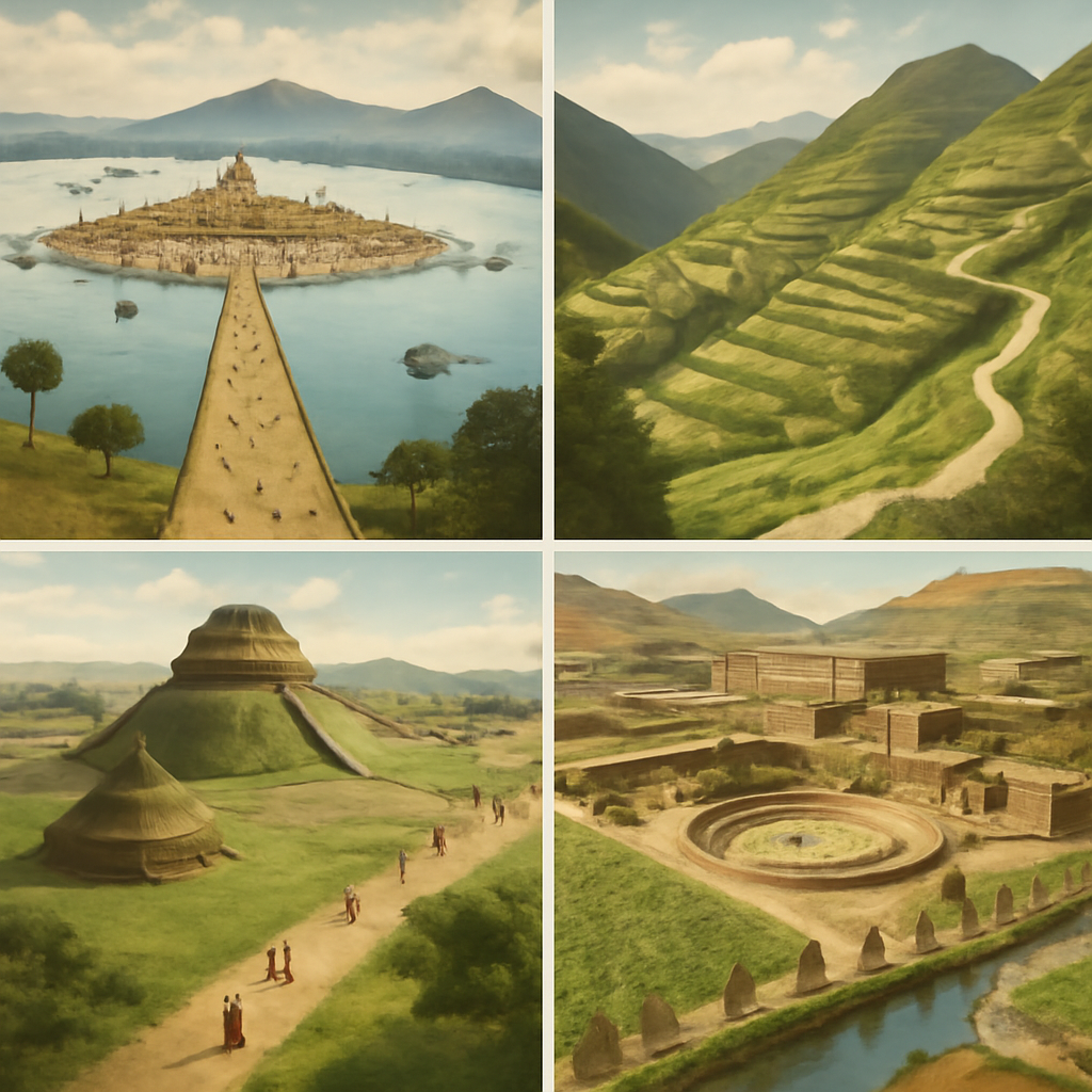
Tenochtitlan Founded
Mexica settlers founded Tenochtitlan on an island in Lake Texcoco, building the urban base for later Aztec imperial power.
Aztec Triple Alliance Forms
Tenochtitlan, Texcoco, and Tlacopan formed the Triple Alliance, creating the political structure behind Aztec imperial expansion.
Inca Expansion under Pachacuti
Pachacuti and his successors transformed the Inca polity around Cusco into a rapidly expanding Andean empire.
Fall of the Aztec Empire
Spanish forces and Indigenous allies captured Tenochtitlan after conflict, epidemic disease, and political fracture undermined Aztec power.
Fall of the Inca Empire
Spanish forces exploited civil conflict, alliances, disease, and coercion to break Inca imperial power and occupy Cusco.
Comparison Grid
Aztec Empire
Tenochtitlan and the Valley of Mexico
Inca Empire
Cusco and the Andean road system
Both had capitals, but geography made authority travel differently.Aztec Empire
Tribute, alliances, markets, and military pressure
Inca Empire
Roads, storehouses, mit'a labor, and provincial administration
The empires used different tools to make distance governable.Aztec Empire
Spanish alliances with enemies of the Mexica mattered.
Inca Empire
Civil war and Atahualpa's capture mattered.
Neither conquest was simply Europeans defeating a passive empire.Fast Frame
Aztec Empire vs Inca Empire is not a simple sequence of events. It is a way to compare power, geography, labor, memory, and evidence across cases that are often separated into national stories.
Mesoamerican lakes and markets created different problems from Andean mountains and road systems. The useful question is not which case matters most, but what becomes visible when the cases are placed on the same route.
A reader arriving from search usually wants a quick answer, but quick answers become misleading when they hide structure. This page keeps the short answer near the top while giving enough route logic for causes, turning points, and afterlives to stay connected.
What Changes When the Route Is Connected
Connected reading keeps the atlas from turning history into isolated summaries. A conquest page needs an Indigenous state before it; an abolition page needs a forced-migration system behind it; a revolution page needs a post-independence state after it.
This structure also helps Google and readers understand that the canonical page is answering one broad intent. The page gathers related terms into a single route instead of splitting near-duplicate pages across the site.
The connected route also makes comparison fairer. Instead of asking one event to carry an entire civilization or region, the page lets several pages share the explanation: a hub for context, a timeline for order, event pages for detail, people pages for agency, and year pages for entry points.
Geography and Scale
Geography is not scenery in this route. Lakes, mountains, ports, islands, plantations, roads, deserts, courts, and capitals decide what kinds of power are practical. A state that can move labor through mountains faces a different problem from a state that depends on ships, forts, or treaty language.
Scale also changes the argument. A village, city, kingdom, empire, plantation zone, treaty system, and international conference do not work the same way. The page keeps moving between scales because historical causation often sits in the gap between local experience and large institutions.
That map-aware structure is useful for readers because dates become easier to remember when each one has a place, a route, and a material problem attached to it.
How to Read Evidence
The evidence changes across the route. Archaeology, inscriptions, oral memory, treaty language, court records, voyage databases, speeches, constitutions, photographs, and climate diplomacy do not produce the same kind of historical voice.
A strong answer keeps those source differences visible. The goal is not to flatten every case into the same pattern, but to let comparison reveal where the pattern breaks.
Official records often preserve the language of states, courts, and empires. Archaeology can show settlement, diet, labor, trade, and ritual without requiring written archives. Oral memory and public commemoration preserve meanings that formal documents often miss.
Actors and Affected Groups
The route keeps famous leaders in view without letting them take over the whole explanation. Rulers, rebels, diplomats, priests, captains, enslavers, merchants, and ministers mattered, but so did farmers, builders, enslaved families, island communities, students, workers, translators, migrants, and survivors.
This matters because many broad history pages become thin when they turn every change into a decision by one recognizable person. The route asks who had power, who carried costs, who interpreted events afterward, and who had to live inside institutions created by others.
A reader can therefore move from a named person to the larger structure around that person. Pachacuti makes Inca expansion easier to enter, but roads and labor systems explain how expansion worked. Liliuokalani makes Hawaiian sovereignty vivid, but land, law, diplomacy, and foreign residents explain why the overthrow mattered.
Causes, Triggers, and Afterlives
The page separates background causes from visible triggers. A battle, treaty, uprising, or law may be the moment people remember, but it usually depended on older pressures: land conflict, labor demand, fiscal strain, racial hierarchy, military technology, ecological risk, or imperial rivalry.
Afterlives matter as much as origins. Conquest created memory and resistance. Abolition created new labor struggles. Independence created state-building problems. Treaty disputes created modern legal and political debates. Climate diplomacy turned older colonial and environmental histories into present-day survival questions.
This cause-trigger-afterlife structure makes the route useful for essays and search answers. It gives the reader a way to answer why something happened, what happened next, and why the event still appears in public memory.
Common Misreadings
One common error is to read the route as inevitable. Conquest was not inevitable, abolition was not inevitable, independence was not inevitable, and reform was not inevitable. People made choices under constraints, and those choices interacted with disease, geography, military power, markets, and institutions.
Another error is to treat the region as empty before outside powers arrived. Indigenous America, the Pacific, and East Asia all had political systems, knowledge routes, and conflicts of their own. Atlantic slavery and Latin American independence also cannot be explained only from European capitals.
The page guards against those errors by giving readers several linked doors into the same subject. If one page feels too narrow, the timeline and hub widen the view; if the hub feels broad, the event and person pages make the argument concrete.
Reader Path
Begin with the hub, then open the timeline to see the order. Move into event pages for causes and consequences, people pages for agency, and year pages when a single date becomes an entry point.
The route is designed for students and curious readers who need a usable structure before they need specialist detail. Each next read answers a concrete question rather than sending the reader to a generic related list.
The best next click depends on the reader's question. A causes question belongs with an explainer or event page; a sequence question belongs with the timeline; a people question belongs with a biography; a broad study question belongs with the hub.
Why This Belongs in a World History Atlas
World history becomes thinner when the Americas, Pacific, slavery, and East Asia appear only when European powers arrive. These routes make older local systems, Indigenous sovereignty, coerced labor, state-building, and modern memory part of the main map.
The page also protects against a common reader-quality failure: a site can have many URLs but still feel shallow if each URL answers only one narrow fact. A comparison or explainer page can hold the larger question together.
The atlas becomes more useful when broad routes and detailed pages reinforce each other. The route gives structure; the individual pages give texture; the sources give readers a way to check the claim.
What the First Screen Must Answer
The first screen has to answer the search query without exhausting the subject. A useful answer names the core contrast, the time span, the geographic setting, and the reason the comparison matters. It also creates a reason to keep reading: there is a hidden structure beneath the familiar label, and the page will make that structure visible.
That opening promise matters for general readers. Many arrive with a school assignment, a half-remembered date, or a phrase from a video or book. They need confidence quickly, but they also need a route that does not collapse into trivia. The page therefore moves from fast answer to evidence, geography, actors, causes, consequences, and reading path.
The page avoids a common generic web-copy failure by refusing to summarize everything at the same temperature. Some details are anchors, some are turning points, some are examples, and some are caveats. Varying their weight makes the page feel guided rather than mechanically exhaustive.
How the Route Handles Uncertainty
Historical evidence is uneven. Some events have official texts, court records, parliamentary debates, or treaty documents. Others depend more heavily on archaeology, oral tradition, material culture, later chronicles, or contested memory. The page keeps that unevenness visible because confidence is part of historical explanation.
Uncertainty does not make the subject vague. It changes the kind of claim a careful page can make. A date may be approximate, a motive may be debated, a number may be an estimate, and a political meaning may differ across communities. Good structure lets the reader see the difference between a firm fact, an interpretation, and a public memory.
This is also a quality control rule for future content generation. A draft is not rich merely because it is long. It needs source-aware language, named places, concrete institutions, and clear limits on what the page knows. When a page cannot support a claim, the workflow goes back to sources or narrows the claim.
How This Page Connects to Deeper Study
The best use of the page is not a single read-through. A reader can use the comparison as a launch point: open the timeline for sequence, open event pages for causation, open people pages for agency, open year pages for chronology, and return to the hub when the larger route becomes blurry.
That pattern is deliberate. The structure stays visible: one main question, supporting examples, and descriptive anchors that name how each next page extends the problem. Internal links are not decoration; they are how the atlas lets a reader move from a broad claim into evidence.
The deeper-study path also keeps the route from becoming shallow. Each connected page has a job: one gives sequence, another gives causation, another gives a person or date, and another opens a broader regional frame. When the jobs are clear, the route feels guided rather than scattered.
Questions That Keep the Page Alive
A strong comparison ends with better questions than it began with. Who had power before the famous event? Which institutions made that power durable? Which groups paid the cost? What changed immediately, what changed slowly, and what remained unresolved? These questions turn a topic from a closed summary into a route for further reading.
The same questions keep the route consistent. Causes and consequences belong with events; chronological and regional structure belongs with hubs; turning points belong with timelines; constraints around individual agency belong with people pages. Without those questions, a large atlas can still feel thin.
A useful page makes a reader want the next click. The next click is not random related content. It is a continuation of the problem the page raised: a date that needs context, a person whose choices need constraints, a place whose geography shaped outcomes, or a later debate that keeps the past active.
City Power and Mountain Power
Tenochtitlan and Cusco make the comparison concrete because each capital solved a different problem. Tenochtitlan sat in a lake basin where causeways, chinampas, marketplaces, tribute flows, and alliance politics made urban power visible. Cusco governed through highland corridors where roads, storehouses, labor drafts, provincial centers, and ritual authority made distance governable.
The Aztec Triple Alliance did not control Mesoamerica as a single uniform state. Tribute lists, allied cities, enemies, markets, ritual obligations, and military pressure created a layered system in which local rulers still mattered. The Inca Empire also depended on local elites, but it integrated them through road stations, labor obligations, census-like recordkeeping, relocation policies, and state storage.
That difference changes how power looks on the ground. The Aztec case often asks how a dominant city could extract tribute from many city-states. The Inca case often asks how a state could move labor, food, messengers, soldiers, and information across mountains. Both were empires, but their everyday mechanics were not the same.
Conquest Without the Passive-Empire Myth
Spanish conquest becomes misleading when it is reduced to a few Europeans defeating enormous empires by superiority alone. In central Mexico, Indigenous rivals of the Mexica, especially Tlaxcalan allies, changed the balance of power. In the Andes, civil conflict after Huayna Capac's death, Atahualpa's position, disease, hostage-taking, and Spanish use of existing political fractures mattered.
Disease was devastating, but it cannot carry the whole explanation. Military technology, horses, steel, ships, diplomacy, religious interpretation, local grievances, political timing, and information failures all interacted. The conquest story becomes richer when it asks which groups saw opportunity, which groups faced terror, and which institutions could not absorb the shock.
The aftermath also differs. New Spain and colonial Peru reused parts of Indigenous labor, tribute, settlement, and administrative systems while violently changing sovereignty, religion, landholding, and wealth extraction. The comparison therefore continues after 1521 and 1533. Conquest was not a single ending; it was the beginning of colonial restructuring.
Memory, Survival, and the Next Read
Modern memory often turns the Aztec and Inca worlds into symbols of lost grandeur, national identity, or tourist monumentality. That can hide living Indigenous languages, communities, land struggles, ritual memory, and scholarly debates over sources. A careful comparison keeps archaeology, colonial accounts, Indigenous continuity, and modern politics in the same frame.
The sources are uneven. Mexica history reaches readers through archaeology, codices, Spanish accounts, Indigenous testimony, and later reconstruction. Inca history relies on archaeology, roads, architecture, quipu debates, Spanish chronicles, and Andean memory. The difference in written record changes what can be said confidently and where caution is needed.
The best reading path is to move from the founding of Tenochtitlan to the Triple Alliance, then to Pachacuti's expansion, and only then to the Spanish conquests. That order gives each empire a history before invasion and prevents the comparison from becoming only a story about collapse.
Reader Checkpoints
Before leaving the comparison, test it with three concrete questions. Which system made surplus visible: tribute lists and market exchange, or storehouses and labor drafts? Which system made distance governable: alliances around lake cities, or roads across highlands? Which system was more vulnerable to local enemies when Spanish forces arrived?
Those checkpoints keep the page from becoming a decorative pair of civilizations. They push the reader back to institutions, geography, and evidence. If the answer names only pyramids, gold, or conquest, the comparison is still too thin.
The strongest short answer can name Tenochtitlan, Cusco, tribute, mit'a labor, roads, markets, Indigenous allies, civil conflict, disease, and colonial restructuring without making any one factor explain everything. That is the level of specificity the comparison is meant to teach.
Continuity also remains visible. Nahua and Andean communities did not vanish after conquest; they negotiated tribute, religion, language, land, labor, and memory inside colonial rule. That afterlife keeps the comparison connected to Indigenous history rather than ending with Spanish victory.
Reader Lenses
Tenochtitlan was a lake city; Cusco governed through mountain corridors and roads.
Aztec tribute and Inca labor obligations organized power through different institutions.
Spanish victory depended on alliances, disease, civil conflict, and imperial vulnerabilities in both cases.
Both empires are remembered through archaeology, Indigenous continuity, colonial writing, and modern national narratives.
Map Layer
Aztec Empire vs Inca Empire geography
Gold pins mark the approximate locations of published event pages. This is a schematic locator map, not a historical border map.
Coordinates are approximate and are used to help readers orient themselves before opening a full event page.
Linked Events
Read the Evidence Trail
Tenochtitlan Founded
Mexica settlers founded Tenochtitlan on an island in Lake Texcoco, building the urban base for later Aztec imperial power.
Aztec Triple Alliance Forms
Tenochtitlan, Texcoco, and Tlacopan formed the Triple Alliance, creating the political structure behind Aztec imperial expansion.
Inca Expansion under Pachacuti
Pachacuti and his successors transformed the Inca polity around Cusco into a rapidly expanding Andean empire.
Fall of the Aztec Empire
Spanish forces and Indigenous allies captured Tenochtitlan after conflict, epidemic disease, and political fracture undermined Aztec power.
Fall of the Inca Empire
Spanish forces exploited civil conflict, alliances, disease, and coercion to break Inca imperial power and occupy Cusco.
References
Where to Check the Facts
- Encyclopaedia Britannica: Mesoamerican civilizationReference for Mesoamerican chronology, cities, religion, trade, and political systems.
- Encyclopaedia Britannica: AztecReference for Aztec political expansion, Tenochtitlan, and the Triple Alliance.
- Encyclopaedia Britannica: IncaReference for Inca state formation, expansion, and Spanish conquest.
- Official UNESCO World Heritage Centre: Lines and Geoglyphs of Nasca and PalpaReference for the Nazca geoglyph landscape and its archaeological significance.